The Plain Record

Neutral daily news — clear headlines, complete facts.

Weather

Hurricane Polo Fluctuates in Intensity off Mexico's Pacific Coast

Hurricane Polo reached Category 5 strength before weakening to Category 4 as it skirts Mexico's coast, bringing threats of flooding and mudslides.

By The Plain RecordUpdated September 24, 2026 at 4:12 AM EDT
Published September 23, 2026 at 12:06 PM EDT

The short answer

Hurricane Polo reached Category 5 strength before weakening to Category 4 as it skirts Mexico's coast, bringing threats of flooding and mudslides. Hurricane Polo fluctuated in intensity off the southwestern coast of Mexico on Wednesday, September 23, 2026.

Updates (2)

  • Update — September 24, 2026 at 4:12 AM EDT: Southwestern Mexico is bracing for heavy rain and mudslides after Polo became a major hurricane in the Pacific.
  • Update — September 23, 2026 at 12:06 PM EDT: Hurricane Polo could bring a surge of moisture to the Southwest, potentially leading to more showers in the region
Hurricane Polo Fluctuates in Intensity off Mexico's Pacific Coast

The Facts

Who
National Hurricane Center, AccuWeather, and the Mexican government
What
Hurricane Polo, a major storm that reached Category 5 intensity, is moving slowly off the coast of Mexico, prompting tropical storm warnings and watches.
When
Wednesday, September 23, 2026
Where
Off the southwestern coast of Mexico in the Pacific Ocean
Why
The storm poses a threat of life-threatening flooding and mudslides to coastal Mexico and could bring significant moisture and flooding risks to the Southwestern United States by next week.

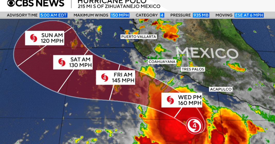
Hurricane Polo fluctuated in intensity off the southwestern coast of Mexico on Wednesday, September 23, 2026. The U.S. National Hurricane Center reported that the storm’s maximum sustained winds reached 180 mph on Tuesday before decreasing to 155 mph by early Wednesday, placing it just below the 157 mph threshold for Category 5 status. While the storm is not expected to make landfall, it is forecast to skirt the shoreline and bring tropical storm conditions to the region.

The storm is currently situated approximately 185 miles off the coast of Zihuatanejo in the state of Guerrero. Forecasters noted that Polo was nearly stationary early Wednesday, moving northward at just 2 mph. The hurricane is the second strongest on record in the Eastern Pacific in terms of central pressure, trailing only Hurricane Patricia in 2015, and is tied for the third strongest in terms of wind speed.

The Mexican government has issued a tropical storm warning from Tecpan de Galeana to Punta San Telmo. A tropical storm watch is also in effect from Punta San Telmo to Playa Perula. Parts of Guerrero and Michoacán are expected to receive between 3 and 6 inches of rain, with localized amounts of up to 8 inches possible through Thursday. AccuWeather meteorologists indicated that while the storm will likely weaken over cooler waters, its moisture could reach the Southwestern United States by next week.

The scale of the storm involves hurricane-force winds extending 40 miles from the center and tropical storm-force winds reaching 105 miles outward. For those in the warning areas, rainfall totals translate to significant accumulations over a short period; for example, up to 8 inches in specific spots. This weather event follows recent flash flooding in south-central Arizona where motorists required air rescues, suggesting that any additional precipitation in those areas could further strain local emergency services and infrastructure.

What happens next: Tropical storm conditions are expected to develop in the warning areas on Wednesday and in the watch areas by Thursday. Forecasters will continue to monitor the storm's path as it heads northwest toward the Baja California peninsula. While the system is expected to lose intensity over cooler waters, meteorologists are watching for a moisture surge into the U.S. Southwest around Monday, September 28, or Tuesday, September 29. No direct landfall is currently forecast for the Mexican mainland or the United States.

Timeline of what happened

Key dates and decisions, in the order they occurred.

  1. September 16, 2026

    Flash floods hit south-central Arizona

  2. September 22, 2026

    Storm reaches 180 mph wind speeds; NHC issues notice

  3. September 23, 2026

    Polo located 185 miles off Zihuatanejo with 155 mph winds

  4. September 24, 2026

    Tropical storm conditions possible in watch areas by this date

Summaries are written by The Plain Record to state the facts of a story plainly and without political slant. Drafted with AI assistance and checked against the source record before publication. See how we report, or report a correction.

← Back to the front page

Questions readers ask

What happened: Hurricane Polo Fluctuates in Intensity off Mexico's Pacific Coast?

Hurricane Polo, a major storm that reached Category 5 intensity, is moving slowly off the coast of Mexico, prompting tropical storm warnings and watches.

Who is involved?

National Hurricane Center, AccuWeather, and the Mexican government

When did this happen?

Wednesday, September 23, 2026

Where did this happen?

Off the southwestern coast of Mexico in the Pacific Ocean

Why does this matter?

The storm poses a threat of life-threatening flooding and mudslides to coastal Mexico and could bring significant moisture and flooding risks to the Southwestern United States by next week.