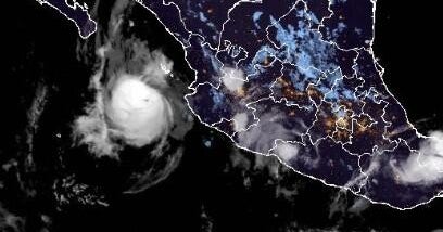
Meteorologists reported that on Sunday, Oct. 11, 2026, the Pacific hurricane region east of the international date line broke the record for accumulated cyclone energy (ACE). Scientists attributed the increased storm intensity and duration to a strong El Niño pattern and warm ocean temperatures. The region, which produces storms that affect Hawaii, Mexico, and the U.S. West Coast, surpassed the previous seasonal energy mark set in 2018.
An El Niño event involves the warming of the equatorial Pacific, which alters global weather patterns. According to researchers, this specific pattern weakens high-altitude vertical winds in the Pacific, creating a "tailwind" effect that allows storms to maintain their structure. Conversely, this same pattern has suppressed activity in the Atlantic, where the first hurricane of the season, Isaias, did not develop until Oct. 7, 2026.
According to Colorado State University researcher Phil Klotzbach, the Pacific is scheduled to tie the record for the most days with an active hurricane on Tuesday, Oct. 13, 2026. The last five Pacific hurricanes—Nolo, Odalys, Polo, Rachel, and Simon—all reached major status with winds of at least 111 mph. Hurricane Polo set an individual record by maintaining Category 5 strength for two-and-a-half days. University of Arizona atmospheric scientist Kim Wood noted that the current season is unique because both subregions of the Pacific are hyperactive simultaneously.
The activity affects coastal residents and travelers in Hawaii, Mexico, and the U.S. West Coast. The scale of the activity is measured by accumulated cyclone energy (ACE), a metric combining wind speed and duration. Hurricane Rachel swamped Las Vegas with remnants over the weekend of Oct. 10-11, while its waves crashed into beachfront homes in Long Beach, California, on Monday, Oct. 12.
Residents in these regions will notice a higher frequency of major storms, defined as having winds of at least 111 mph. The phenomenon also illustrates a divide in regional weather, as the Atlantic basin experienced its longest stretch without a hurricane on record during the same period, with ACE levels there at less than 18% of the seasonal norm.
What happens next depends on a weather disturbance currently off the Mexican coast. The National Hurricane Center reported a 90% chance that this system will develop into Tropical Storm Trudy. Scientists expect favorable conditions for storm formation to continue due to the ongoing El Niño and a counterclockwise atmospheric spin known as a gyre located over Central America. No specific end date for the hyperactive period was reported, though researchers stated the trend is expected to continue "for a bit."