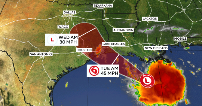
The National Hurricane Center issued a tropical storm warning for portions of the Texas and Louisiana coasts on Monday as a weather system formed in the Gulf of Mexico. The Miami-based center designated the system as Potential Tropical Cyclone Five, noting it would be named Tropical Storm Edouard if its development continues as expected.
The system is the fifth of its kind to develop during the 2026 Atlantic hurricane season. Forecasters tracked the system on Monday morning moving slowly westward, located approximately 130 miles from Morgan City, Louisiana, and 230 miles from Port Arthur, Texas.
As of 11 a.m. ET on Monday, the system recorded maximum sustained winds of 35 mph. While this is currently below the 39 mph threshold required for official classification as a tropical storm, the National Hurricane Center stated that the system is expected to strengthen over the next day or so. The latest forecast indicates the storm could reach the Gulf Coast by Tuesday.
Residents and business owners in coastal southeastern Texas and southwestern Louisiana are affected by this warning. The warning area spans from Port Bolivar, Texas, to the Vermilion/Cameron Parish Line in Louisiana. The National Hurricane Center reported that these communities should prepare for tropical storm conditions—including strong winds and potential flooding—to arrive within 24 to 36 hours.
The scale of the impact involves predicted rainfall and potential property hazards. Forecasters expect 3 to 6 inches of rain across parts of coastal and east-central Texas, with localized totals reaching up to 9 inches. Southwestern Louisiana is projected to receive between 2 and 3 inches. For residents in low-lying and urban areas, this level of precipitation may result in flash flooding. Additionally, coastal areas face a potential storm surge of up to 3 feet.
A tropical storm warning indicates that hazardous conditions are expected within the warning area. The National Hurricane Center will continue to monitor the system's wind speed and trajectory as it approaches land. The system is forecast to reach the coast on Tuesday.