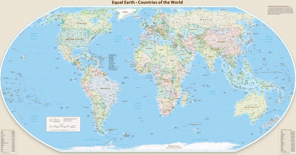
The United Nations General Assembly on Friday, September 4, 2026, adopted a resolution to encourage the use of a world map projection that represents the continent of Africa at its true relative size. The "Correct the Map" resolution, sponsored by Togo on behalf of the 54-member African Group, passed with 164 votes in favor and one against. The United States was the sole nation to vote against the measure, while six countries—Estonia, Georgia, Lithuania, Moldova, Serbia, and Ukraine—abstained.
The resolution encourages governments, media, and educational institutions to transition from the 16th-century Mercator projection to equal-area maps like the Equal Earth projection. Developed in 2018, the Equal Earth map seeks to provide a more proportionally accurate depiction of landmasses. While the Mercator map is traditionally used for maritime navigation because it preserves straight compass bearings, geographers note it distorts the size of regions near the poles, making Greenland appear roughly the same size as Africa. In reality, Africa is approximately 14 times larger than Greenland.
Togo's Foreign Minister Robert Dussey stated before the vote that maps "shape our understanding of the world" and influence collective perceptions. Supporters, including the advocacy group Africa No Filter, argue the change will correct decades of misinformation regarding Africa's geographic importance. Conversely, Yaryna Ferencevych, a U.S. representative to the U.N., criticized the resolution as an "ideological agenda" that distracts from more pressing international issues, stating it damaged the institution's credibility.
For the 54 member states of the African Union, the scale of this change involves correcting the visual representation of approximately 30.4 million square kilometers of land. The resolution aims to ensure that the billions of people who interact with digital and physical maps daily see Africa at its actual scale, where it is large enough to contain the landmasses of the United States, China, India, Japan, Mexico, and much of Europe combined. French Foreign Minister Jean-Noël Barrot announced following the vote that his ministry would stop using the Mercator map.
The concrete day-to-day change for most people will occur as educational publishers and software developers update their materials to align with the U.N.'s recommendation. Students may eventually see a globe-like rounded map in classrooms instead of the rectangular Mercator grid, which geographers like Mark Monmonier of Syracuse University argue has little use outside of specific navigation applications. The African Union previously adopted the Equal Earth projection in February 2026, setting the stage for this broader international push. The next steps involve individual member states deciding whether to integrate the new projection into their national curricula and official government communications.