The Plain Record

Neutral daily news — clear headlines, complete facts.

Weather

First Northeast Snowfall and Eastern U.S. Cold Snap Forecast for Later This Week

A cold snap is forecast to bring temperatures 20 to 25 degrees below average to the eastern U.S., with snow expected in the interior Northeast.

Published November 10, 2026 at 12:51 PM EST

The short answer

A cold snap is forecast to bring temperatures 20 to 25 degrees below average to the eastern U.S., with snow expected in the interior Northeast.

First Northeast Snowfall and Eastern U.S. Cold Snap Forecast for Later This Week

The Facts

Who
Residents of the eastern U.S., including those in Chicago, Atlanta, and the Northeast.
What
First seasonal snowfall and a widespread cold snap.
When
Starting Wednesday through the upcoming weekend.
Where
The eastern half of the United States, specifically the Northeast, Midwest, and South.
Why
A dip in the jet stream and a strengthening storm system are moving cold air from Canada toward the Gulf Coast.

Meteorologists forecast the first snowfall of the season for parts of the interior Northeast later this week as a cold snap moves across the eastern United States. A dip in the jet stream is expected to bring temperatures between 20 and 25 degrees below the seasonal average, affecting a region stretching from the Canadian border to the Gulf Coast.

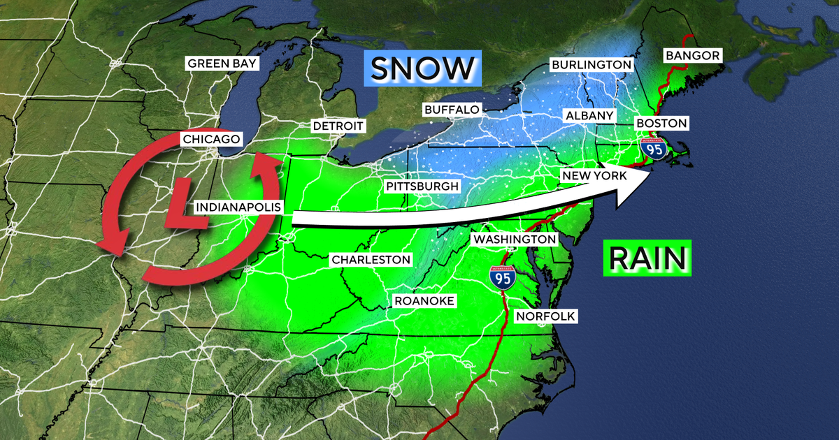
The weather pattern is driven by a storm system developing over the Midwest on Wednesday that is projected to strengthen as it moves toward the Northeast. While coastal cities and the I-95 corridor are expected to receive cold rain, higher elevations and interior areas are likely to see snow.

Forecasts indicate that overnight "feels-like" temperatures will drop near or below freezing in major cities, including Chicago and Atlanta. Daytime high temperatures are expected to remain in the mid-30s and 40s from Thursday through the upcoming weekend.

For travelers and commuters in the Northeast, the transition from rain to snow in higher elevations and interior regions like upstate New York, New Hampshire, and Vermont may affect road conditions. In coastal cities such as Boston, New York, Philadelphia, and Washington, D.C., the primary impact will be cold rain and temperatures significantly lower than typical seasonal norms.

A second, smaller storm system could potentially form off the Mid-Atlantic coast, which would further influence precipitation levels. Meteorologists are monitoring the path of this secondary system to determine the distribution of rain and snow. The cold weather is expected to persist through the weekend.

Summaries are written by The Plain Record to state the facts of a story plainly and without political slant. Drafted with AI assistance and checked against the source record before publication. See how we report, or report a correction.

← Back to the front page

Questions readers ask

What happened: First Northeast Snowfall and Eastern U.S. Cold Snap Forecast for Later This Week?

Meteorologists forecast the first snowfall of the season for parts of the interior Northeast later this week as a cold snap moves across the eastern United States. A dip in the jet stream is expected to bring temperatures between 20 and 25 degrees below the seasonal average, affecting a region stretching from the Canadian border to the Gulf Coast.

Who is involved?

Residents of the eastern U.S., including those in Chicago, Atlanta, and the Northeast.

When did this happen?

Starting Wednesday through the upcoming weekend.

Where did this happen?

The eastern half of the United States, specifically the Northeast, Midwest, and South.

Why does this matter?

A dip in the jet stream and a strengthening storm system are moving cold air from Canada toward the Gulf Coast.